| Home | ||||||||||||||||||||||||||||||||
| SLIABH BÁN / landscape |
|
|||||||||||||||||||||||||||||||
|
||||||||||||||||||||||||||||||||
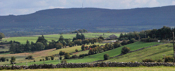
| Proposed destruction of Roscommon's most visible and best loved landmark | ||||||||||||||||||||||||||||||||
|
Coillte's proposed windfarm development would have a
devastating impact on the character of the Roscommon landscape. The site
in question is 833 hectares and covers most of the mountainside of Sliabh
Bán. The mountain is oriented north-south, being approximately 3km in
width and up to 7km in length. The imposition of 20 turbines spread across
the mountain changes utterly the character of the landscape as the natural
image unit of Sliabh Bán would be dominated by the structures. According to Section 2.5.3, Coillte owns over 445,000 hectares of land; about 7% of the land cover of Ireland and much of the best wind regimes in Ireland are on Coillte lands – and yet the EIS considers only two other local sites as alternatives to Sliabh Bán. These alternative sites are listed Option 1, 2 and 3 in one paragraph and, rather confusingly, Sites 1, 2 and 3 in Table 2.3 – Site Comparison Matrix. Interestingly, Sliabh Bán is referred to as Option 3 in Section 2.5.3 and yet Site 2 in Section 2.5.4 is scored the highest in the Site Comparison Matrix. This sloppy approach to site comparisons further undermines the attempt at researching realistic alternatives to the Sliabh Bán. The scoring system applied to each of the three sites is confusing, unreliable and inconsistent – since Site 2 scores “highest”, we can take it refers to Sliabh Bán – yet it scores the same as Site 1 in relation to Dwellings, Grid Connection and Electromagnetic Interference. The differences between the two sites, as described in Section 2.5.3 would indicate there are very few similarities between the feasibilities of these sites. Moreover the lack of a coherent approach to assessing alternative sites for this development raises questions about the developers' motives for selecting Sliabh Bán. The fact that Sliabh Bán appears to be a convenient site for the developers, given its access to the grid, should not override the principles of proper planning and sustainable development. |
||||||||||||||||||||||||||||||||
|
● Wrong sites for windfarms The West Regional Planning Guidelines (RPG) offer some direction in relation to appropriate areas of the region with potential for development. “It is expected that wind energy will play a proportionally larger role in the energy mix in the West in the future. However, in order for this to occur there is a need to make better use of the wind resources on the western sea-board than is being done at present.”(Section 3: Key Issues and Strategic Goals). The RPG go on to say in Section 6, that “New wind farm developments must be in compliance with the principles of proper planning and sustainable development.” Part of the appraisal of a development of this magnitude should involve the investigation of realistic alternatives to the site proposed. The Department of the Environment Guidelines on Wind Energy Developments (DoEHLG Guidelines), 2006, have been largely ignored in this planning application. Not surprising when these Guidelines warn against developments that visually dominate the landscape. This site ranges in elevation from 70m to 262m OD (Malin Head), indicating a change in height of approximately 192 metres. The 20 turbines proposed for Sliabh Bán reach an overall height of 131.5 metres arranged across the whole site. There are no mitigating factors that could possibly reduce the impact of this obtrusive and imposing development. The DoEHLG Guidelines advise that “the spatial extent of a wind energy development should be balanced and in scale with its landscape context. This involves consideration of the perceived size (extent and height) of landform, landcover and structures relative to the wind energy development” (Section 6.4). In the case of this planning application, the proposed wind farm is too spatially extensive relative to the scale of the mountain. There is no extensive mountainous range to shield views or absorb the development; a single mountain ridge like Sliabh Bán does not have the visual capacity or expanse of scale to sustain an industrial installation of this size. As indicated in the DoEHLG Guidelines, when turbines are too high relative to the scale of the hill, this results in spatial dominance (see Fig 11 in DoEHLG Guidelines). The layout and spacing of the turbines is not justified in any context relating to their visual impact but the position of the turbines seems to have been largely determined by exclusion zones around dwelling houses, watercourses and transmission masts. The DoEHLG Guidelines (sections 6.6 and 6.7) encourage developers to consider layout and spacing of turbines to avoid the creation of a “visual stacking” effect. With reference to Transitional Marginal Landscapes (Section 6.9.4 DoEHLG Guidelines), which probably coincides best with the landscape around Sliabh Bán for the purposes of applying the recommendations of these guidelines, the document highlights the visual complexity of the landscape, due to the diverse landform and landcover and advises that “wind energy developments should avoid adding to such complexity due to the risk of creating visual confusion and conflict.”(Section 6.9.4) Yet Coillte propose 20 wind turbines, a communications mast, a meteorological mast, an electrical compound and substation building as well as hardstanding areas, drainage and site works on the one site.
●
Wrong positions for turbines One of the key tools in determining the visual impact of this
development are the resources supplied by the developer such as the
computer generated Zones of Theoretical Visibility and the photomontages
from different view shed reference points and this is emphasised in Policy
198 of the County Development Plan. Furthermore, the DoEHLG Guidelines
clearly state that for blade tips in excess of 100m (in height), a Zone of
Theoretical Visibility radius of 20km would be adequate (see Appendix 3 of
DoEHLG Guidelines), and yet the developer’s EIS only considers a study
area with a 15km radius centred on the location of the proposed
development claiming that “Visual impacts received by receptors beyond
15km from the development are not considered to be of significance”
(section 11.3.2). This rather throwaway remark, not backed up by any
reference, belittles the significance of Sliabh Bán has the highest peak
in east Roscommon and impairs the opportunity to properly review the
disastrous visual impact this development would have on the landscape.
●
Assessing the visual impact by
photomontages The photomontages provided with this planning application are
clearly deficient in providing the necessary detail to properly asses the
visual impact of this proposed development on the landscape. The
assessment of these photomontages in the EIS raises questions about the
developer’s appreciation of the visual significance of Sliabh Bán as an
image unit on the landscape.
● Protection for our natural landmark The LCA description of this landscape points out that Sliabh Bán
“creates a strong visual separation between the Shannon River and the
remainder of the county in this area” before going on to say that
“elevated views from Slieve Bawn to the east are of a highly mechanised
landscape of commercial peatland and the peat burning electricity plant in
the distance at Lanesborough”. It is imperative that Roscommon County
Council does not allow this strong visual separation to become blurred by
the imposition of twenty large wind turbines and allow the mechanised,
commercial and industrial landscape to the east of the mountain to creep
up and across the ridge. |
||||||||||||||||||||||||||||||||
| Home | ||||||||||||||||||||||||||||||||